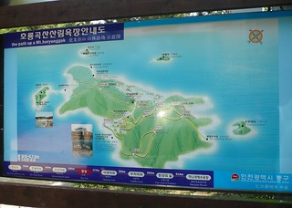
Just in case you've visited Muuido for a hike, and are lost, here's a copy of the island map (무의도 등산로 지도) that's displayed at multiple points along the hiking trails. Also, here's a detail of the map timetable, estimating hike times between key points.
I took these photos, but various other (clearer) photos can be seen here (hiking trail maps) or here (general island maps). Here's a nice once, for example:
And FYI, the ferry back to the 'mainland' (Jamjindo, and walk to Yeongjongdo, from which you can catch the Airport Railroad) departs Muuido at every half-hour, the last departing at 7:30pm (Mon, Wed, Th) or 8:00pm (Sun, Tues, Fri, Sat). Check the specific timetables here:
→ Muuido Ferry Departures Timetable
 |
| Muuido Island hiking trails map |
 |
| Muuido island table of distances and approximate walking times between key points |
I took these photos, but various other (clearer) photos can be seen here (hiking trail maps) or here (general island maps). Here's a nice once, for example:
And FYI, the ferry back to the 'mainland' (Jamjindo, and walk to Yeongjongdo, from which you can catch the Airport Railroad) departs Muuido at every half-hour, the last departing at 7:30pm (Mon, Wed, Th) or 8:00pm (Sun, Tues, Fri, Sat). Check the specific timetables here:
→ Muuido Ferry Departures Timetable
Comments